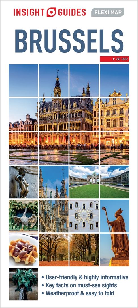
Insight Guides Flexi Map Brussels
for Over 50 Years
Local Insights
for On-The-Go Exploration
from Publisher
Processing
Description
Insight Guides Flexi Map Brussles
This easy to use, full-colour, waterproof map is all you need to navigate Brussels. It also includes handy destination detail on Saint-Gilles area, and tips on top attractions and getting around.
· Combines clear, up-to-date cartography with destination detail, stylish design and stunning photography
· The main map is at a scale of 1:60 000, with prominent public buildings, hotels and other places of interest highlighted in the extensive index
· Secondary maps cover Bruges and Spa
· But it's also much more than a map - includes tips on top attractions, galleries, museums, heritage sites, travelling further afield, and getting around
· Laminated finish is tough, waterproof and can be written on with a non-permanent marker pen - just write and wipe as required
About Insight Guides: Insight Guides is a pioneer of full-colour guide books, with almost 50 years' experience of publishing high-quality, visual travel guides with user-friendly, modern design. We produce around 400 full-colour print guide books and maps, as well as phrase books, picture-packed eBooks and apps to meet different travellers' needs. Insight Guides' unique combination of beautiful travel photography and focus on history and culture create a unique visual reference and planning tool to inspire your next adventure.
Book Details
Series
This title is a part of Insight Guides Flexi Maps
Stylishly-designed, laminated maps, combining clear, up-to-date cartography with handy tourist information and selection of recommended sights, enhanced by stunning photography.
Slim-line, lightweight maps featuring all the primary areas of interest for a destination
Extended selection of recommended sights and points of interest with descriptions, all with coordinates to the relevant grid on the mapping
Essential information, such as getting from the airport, getting around, money and emergency numbers, is featured
Laminated finish is tough, weatherproof and can be written on using a non-permanent marker pen
Stylish design features several full-colour photos of the destination
Clever fold makes the maps easy to use - and put away
Format: 100 x 218mm (folded)
Price: £5.99 | $9.99
FAQs
Which payment options can I use in the Rough Guides Shop?
You can pay with credit card: Visa, MasterCard, American Express, and via PayPal.
How long will it take to receive my order from the Rough Guides Shop?
If you’ve ordered an ebook, it will be delivered to you via email immediately after your purchase.
For printed book orders, we offer DPD next day delivery in the United Kingdom and Northern Ireland and standard (2-8 days), priority (1-3 days) delivery options in the USA.
Please be aware that the delivery times are based on when your item was dispatched and not when you ordered your item. Unless stated otherwise, we intend to send items on the next available business day.
Currently we do not provide a tracking number for your order.
How can I contact Rough Guides about a shop order?
You can contact our shop team at "[email protected]".
To help our team reply faster, please copy and use one of the following email subject lines:
- "Book shop: orders, shipping, returns"
- "Website: general usage and technical problems"
- "Guide books: corrections and other questions"
- "Tailor-made travel"

for Over 50 Years
Local Insights
for On-The-Go Exploration
from Publisher
Processing
Description
Series
FAQs
Insight Guides Flexi Map Brussles
This easy to use, full-colour, waterproof map is all you need to navigate Brussels. It also includes handy destination detail on Saint-Gilles area, and tips on top attractions and getting around.
· Combines clear, up-to-date cartography with destination detail, stylish design and stunning photography
· The main map is at a scale of 1:60 000, with prominent public buildings, hotels and other places of interest highlighted in the extensive index
· Secondary maps cover Bruges and Spa
· But it's also much more than a map - includes tips on top attractions, galleries, museums, heritage sites, travelling further afield, and getting around
· Laminated finish is tough, waterproof and can be written on with a non-permanent marker pen - just write and wipe as required
About Insight Guides: Insight Guides is a pioneer of full-colour guide books, with almost 50 years' experience of publishing high-quality, visual travel guides with user-friendly, modern design. We produce around 400 full-colour print guide books and maps, as well as phrase books, picture-packed eBooks and apps to meet different travellers' needs. Insight Guides' unique combination of beautiful travel photography and focus on history and culture create a unique visual reference and planning tool to inspire your next adventure.
BOOK DETAILS


.jpeg)
